1


                                                                                                 Live Weather Cam (incl. motion) - NW view
This website works MUCH better with Mozilla type browsers (Firefox, Seamonkey)
Some links in left column may need to be right-clicked and opened in new window.
In some browsers, page or webcam pics may need to be force refreshed for latest.

12

Report from nearest NOAA/FAA station

KROA - ROANOKE AIRPORT, 8 mi. NNE - Elev. 1186'
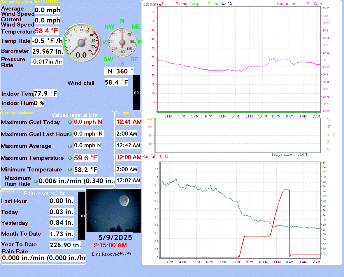
Click for the latest Roanoke weather forecast.

        Local Private Station Report - Elev. 1500'

        Located 8 mi. SW KROA (airport)

06:45 AM EDT 4/4/2026

Wx: Dry  

Temp 60.7°F Precip. Hour:
             Day:
0.00
0.00 in.

Hi/Lo 67.0°F/60.4°F    Yesterday: 0.00 in.
Wind
1.3 mph WNW Gust (hr.) 7.7 mph NNE 5:45 AM
Dew Point
52.0°F  hum 73
Gust (day) 19.6 mph 2:44 AM
Barometer  30.283 in.   Trend  +0.006in./hr   

Snowfall 2025-26:  airport = 13.9"    wx station = 18.5"      Average=22"/yr.


National Weather Service Forecast for: Roanoke VA
Issued by: National Weather Service Blacksburg, VA
Updated: 6:30 am EDT Apr 4, 2026

Roanoke, VA
 
Today

Today: Mostly sunny, with a high near 84. Light southeast wind becoming south 9 to 14 mph in the morning.
Mostly Sunny

Tonight

Tonight: A slight chance of showers before midnight, then a slight chance of showers and thunderstorms after 5am.  Partly cloudy, with a low around 59. South wind around 11 mph, with gusts as high as 21 mph.  Chance of precipitation is 20%.
Slight Chance
Showers then
Partly Cloudy
Sunday

Sunday: Showers and thunderstorms likely, then showers after 8am.  High near 70. West wind 9 to 13 mph, with gusts as high as 23 mph.  Chance of precipitation is 100%. New precipitation amounts between a tenth and quarter of an inch, except higher amounts possible in thunderstorms.
Showers

Sunday
Night
Sunday Night: A chance of showers before 8pm.  Partly cloudy, with a low around 42. Northwest wind around 11 mph, with gusts as high as 20 mph.  Chance of precipitation is 30%. New precipitation amounts of less than a tenth of an inch possible.
Chance
Showers then
Mostly Clear
Monday

Monday: Sunny, with a high near 66. West wind 6 to 10 mph, with gusts as high as 20 mph.
Sunny

Monday
Night
Monday Night: Mostly clear, with a low around 42.
Mostly Clear

Tuesday

Tuesday: Sunny, with a high near 60.
Sunny

Tuesday
Night
Tuesday Night: Clear, with a low around 32.
Clear

Wednesday

Wednesday: Sunny, with a high near 60.
Sunny

Hi 84 °F Lo 59 °F Hi 70 °F Lo 42 °F Hi 66 °F Lo 42 °F Hi 60 °F Lo 32 °F Hi 60 °F


Today
 
Mostly sunny, with a high near 84. Light southeast wind becoming south 9 to 14 mph in the morning.
Tonight
 
A slight chance of showers before midnight, then a slight chance of showers and thunderstorms after 5am. Partly cloudy, with a low around 59. South wind around 11 mph, with gusts as high as 21 mph. Chance of precipitation is 20%.
Sunday
 
Showers and thunderstorms likely, then showers after 8am. High near 70. West wind 9 to 13 mph, with gusts as high as 23 mph. Chance of precipitation is 100%. New precipitation amounts between a tenth and quarter of an inch, except higher amounts possible in thunderstorms.
Sunday Night
 
A chance of showers before 8pm. Partly cloudy, with a low around 42. Northwest wind around 11 mph, with gusts as high as 20 mph. Chance of precipitation is 30%. New precipitation amounts of less than a tenth of an inch possible.
Monday
 
Sunny, with a high near 66. West wind 6 to 10 mph, with gusts as high as 20 mph.
Monday Night
 
Mostly clear, with a low around 42.
Tuesday
 
Sunny, with a high near 60.
Tuesday Night
 
Clear, with a low around 32.
Wednesday
 
Sunny, with a high near 60.
Wednesday Night
 
Mostly clear, with a low around 35.
Thursday
 
Sunny, with a high near 69.
Thursday Night
 
Mostly clear, with a low around 45.
Friday
 
Sunny, with a high near 76.


Forecast from NOAA-NWS for Roanoke VA.

-->


ZONE FORECAST - Issued by local NWS office:

Expires:202604041400;;804053
FPUS51 KRNK 040634
ZFPRNK

Zone Forecast Product for Virginia
National Weather Service Blacksburg VA
233 AM EDT Sat Apr 4 2026


VAZ022-041400-
Roanoke-
Including the cities of Roanoke and Salem
233 AM EDT Sat Apr 4 2026

.REST OF TONIGHT...Partly cloudy. Near steady temperature in the
mid 60s. Southwest winds 5 to 10 mph with gusts up to 20 mph. 
.SATURDAY...Mostly sunny. Highs in the lower 80s. Southwest winds
10 to 15 mph. Gusts up to 30 mph in the afternoon. 
.SATURDAY NIGHT...Partly cloudy. Lows in the upper 50s. Southwest
winds 15 to 20 mph with gusts up to 35 mph. 
.SUNDAY...Showers. Not as warm with highs in the upper 60s. West
winds 15 to 20 mph with gusts up to 35 mph. Chance of rain near
100 percent. 
.SUNDAY NIGHT...Partly cloudy with a chance of showers in the
evening, then mostly clear after midnight. Much cooler with lows
around 40. Northwest winds 10 to 15 mph with gusts up to 30 mph.
Chance of rain 30 percent. 
.MONDAY AND MONDAY NIGHT...Mostly clear. Highs in the mid 60s.
Lows in the lower 40s. 
.TUESDAY...Sunny. Highs in the upper 50s. 
.TUESDAY NIGHT...Clear, colder with lows in the lower 30s. 
.WEDNESDAY AND WEDNESDAY NIGHT...Mostly clear. Highs in the upper
50s. Lows in the mid 30s. 
.THURSDAY AND THURSDAY NIGHT...Mostly clear. Highs in the upper
60s. Lows in the mid 40s. 
.FRIDAY...Sunny. Highs in the mid 70s. 

$$


for local National Weather Service homepage - Blacksburg, VA

This weather web site is operated to provide additional weather data. Every effort is made to update the data on

regular basis but there may be occasions when equipment downtime or other factors will affect that effort.

Weatherdata is believed to be accurate for the area where sensors are located. However, no guarantees are

associated with that information. When making important weather related decisions NEVER depend on weather

information from this web site.... or any web site(s) other than those operated by the National Weather Service.

CLICK HERE to email site manager
75.6